

|
|
It's been the perfect Summer for me with a rich bounty of yin and yang weather events which has kept me very busy clocking up the miles on the road and chasing storms once again. This Spring and Summer has already been a personal record for me for I've done more storm chasing than I've ever done before and even more so than the action packed intense chases during the Summer of 2013. This Summer has been absolutely perfect for my kind of interests with weeks of warm or even hot humid weather with with higher than average sunshine, however these same conditions have also triggered regular episodes of showers and thunderstorms which have been most prolific along the west and south west of Ireland with slow moving high precipitation thunderstorms being the order of the day, these storms have lured me out on the road numerous times and enticed me to chase to Co. Fermanagh, Sligo and Co. Leitrim on many days - often in a row - in the search for photogenic storm action, some of these days were successful, a few were strong cap busts, many have been unphotogenic however several days have been very kind to the camera when the light and visibility was good, regardless of the out come I have enjoyed every single one of these chases and have learned new things about the countryside, roads, the storms and forecasting not to mention my own strengths and weaknesses, however more than anything else I have learned to listen to my instincts which is something which can only be developed from such constant practice and experience.
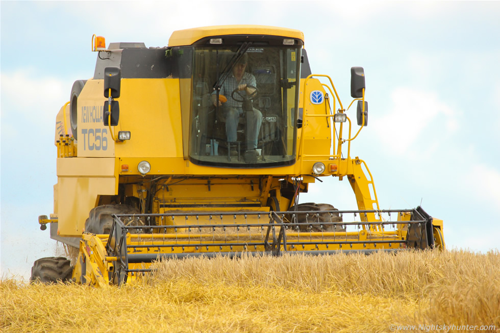 |
The warm weather has been a great time for farmers and during the end of July the presence of farm machinery in the fields was prolific. I have always loved watching tractors and combine harvesters ar work in hay fields with the round golden bales stacked on view under a blazing sun, the visual sights and scent of the fields always brings me back to my childhood watching the same scenes on Summer evenings when the days seemed to last forever. I have always wanted to get an image of a combine harvester in N. Ireland however I have never succeeded in doing so because I have not seen that many about and the few I have observed where in fields adjacent to busy roads were pulling over for images was simply not an option, however I finally got my chance during a stifling warm July afternoon while heading to the north coast, I encountered this combine at work in the fields outside Portrush and this time I didn't let the opportunity pass, there was even a lay by opposite the fields on the other side of the road which looked like it was made for me, I grabbed the camera and attached the Canon 100-400mm lens, crossed the road, climbed the steep grass embankment and got my elbows rested on a fence post, zoomed into 400mm, then the combine appeared over the brow of the hay field facing me head-on and I got my shot, even though the combine was at the other end of the field I was able to full the frame with this powerful lens and through the viewfinder I could see the driver in the cab and even saw his eyes moving, I couldn't have asked for better than that.
On August 2nd a Sly frontal system with very high rainfall rates moved across the eastern portion of N. Ireland producing torrential rain and flooding on the roads, it got so bad that a large landslide of mud and earth was captured on video in Co. Antrim on the hills outside Cushendal, the footage was featured on the main news and was highly impressive and more like a scene from another country, local farmers who have been living there all their lives said they had never seen anything like it before. That same night Roisin and I watched a beautiful sunset over Cookstown while further to the N and W a stunning large scale mammatus display was captured over the north coast and Donegal, I really wish I had seen that one. The morning of August 3rd couldn't have been any different than the previous evening, the front had cleared and the sky was blue and clear with bright sunshine and rapidly building heat. Roisin and I where staying at my Dad's house in Cookstown and getting ready for an afternoon storm chase, as we ate breakfast we had the back door wide open and watched the sunshine and listened to the birds singing.
The latest models showed a Wly flow with over 1000 CAPE and LIs of -3 with convergence and even some speed shear which is something which had been lacking in a lot of storms this season. Vertical wind shear is very important if you want to get stronger thunderstorms, without shear an updraught goes up then produces precipitation which falls straight back down again through the base, this is the same as breathing in and out then your breathing in gets shut off then your suffocate and stop briefing entirely, this is what it's like for a storm with no wind shear, after a brief moment of life - typically 20-30 min's or so (if you are lucky at that) the cell will drown in it's own precipitation, these are called garden variety thunderstorms or pulse storms. If you have speed shear aloft the updraught then gets blown forward away from the base, you can see this visually as the tower/updraught tilted forward rather than being vertical, when this occurs precipitation falls away from the base allowing the cell to breath in and out and hence becoming organised with a longer life cycle with a higher chance of severe weather. Today storms would be organised and with pockets of convergence there was also be a risk of funnel clouds and weak tornadoes, in fact, ESTOFEX had a level 1 issued for N. Ireland and Scotland for this vary reason.
 |
By late morning it was warm and humid with impressive convection developing which was quite tall and sharp for so early in the day, I could see it expanding rapidly in real time which was a great sign, it was nice standing out in the back yard under the wonderful sun with beautiful white towers boiling merrily and full of promise as I drank my berocca, I noticed with great delight that the towers were leaning slightly forward which was the visual indication that there was wind shear aloft, I knew then that if a cell could develop we could be in business however it needed to happen within the next few hours as the CAPE would move into the east by 16.00 then gone from the east coast by 18.00. After midday we hit the road and drove N then stopped at the filling station in Moneymore to enjoy a much needed ice lolly to cool down, the atmosphere at this time felt very 'close' and Roisin commented on the fact that it felt like something was going to happen, we watched towers grow over the station then to our west it looked heavy and dark as if something was brewing, it was then that I got a text message from my Dad who was at the north coast informing me that storms were building and heading inland so we finished up then got back once again on the road.
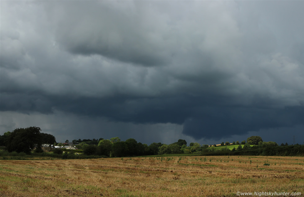
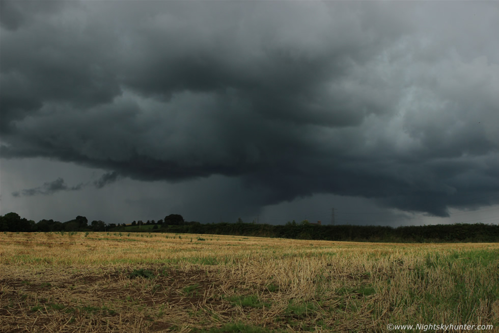
Once we cleared the obstructing buildings and trees outside Moneymore we could see a very threatening sky to the west which looked like a storm, last time I checked the charts there was no lightning so I wondered if it was sparking, it was clear a big cell had formed to the W on the trough and was now moving E and it really looked the part so we kept going N getting closer, when we entered the countryside outside Desertmartin we had a brilliant view of the cell and with good fortune I found a small lay by near a hedge beside a field and managed to squeeze the car in, then Roisin and I got out to watch. Here's the cell to the west over the Sperrins moving R to L, Slieve Gallion is located out of the frame to the L, the tall towers and anvil were hidden from view by mid level cloud however they would have been located far above the top of this frame.
 |
I was using the Canon 24-70mm F/2.8 which I have now fallen in love with for storm photography, before this my main lens for weather was the 18-55mm kit lens and Canon 10-22mm ultra wide angle lens, I still use both when the circumstances require these focal lengths however I have found the 24-70mm to be extremely versatile covering that range from semi wide to low end zoom and all with a fast focal length for low light, the images from this lens are incredibly sharp and clean so I will now be employing it for future storm photography. It was fortunate that we stopped here because the farmer had left the gate wide open so we were able to walk into this freshly cut hay field which provided us with an excellent view of the storm with base clearly visible and a very photogenic landscape for composition, we heard thunder rumble and I shouted ''yes!!!'' with my fist in the air, we had success already and it was only 13.00 in the afternoon, Roisin and I were both buzzing with delight, Roisin also began taking images and video using her Samsung Galaxy smart phone, we were both in our element.
 |
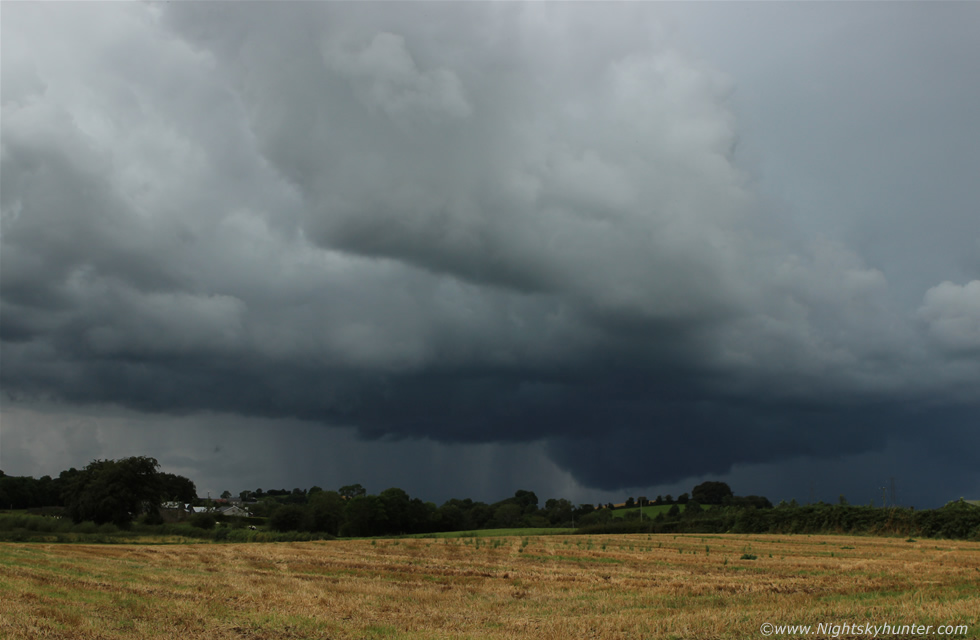
The storm had a large solid bowl-shaped lowering close to the fields and I was pretty certain I could make out slow rotation on the S (L) side of the lowering for a while. This was taken at 50-60mm, the storm growled again adding to the excitement.
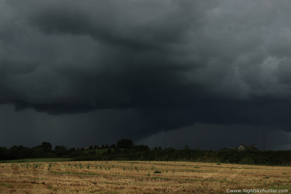 |
This was the first storm of the day in N. Ireland and it was clear it had exploded to life over the Sperrins where no doubt it was helped along by orographic lift from the mountains and now taking advantage of the shear aloft and becoming a slow moving organised storm, it was producing a tidy number of sferics on the charts and strengthening by the minute. This image matches the real life view of the storm base, I deliberately exposed the scene this way to match the naked eye view, that's how dark the storm was with just enough sunshine in the clear sky to the east to light up the field.
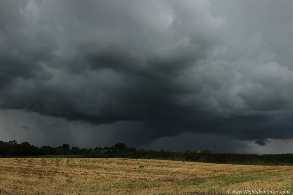 |
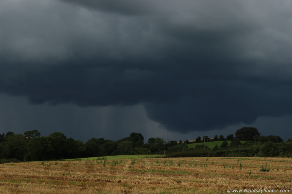
By this stage it was already sporting some of the finest storm structure I have seen this year to date and only coming second best to the spectacular Dungiven thunderstorm back in May this year which still holds the prize of first place for storms this year for me as far as photogenic structure is concerned. We were both very impressed by the appearance of this brutal looking cell, the clouds were dark and threatening and very solid which are traits I like to see and it was very camera friendly too, I couldn't stop taking images, I kept snapping away then I set up my video camera on a fence post and let it record the scene while I continued taking still images. We saw lightning in the precip to the L of centre and to the R in the form of white bolts flashing and whipping horizontally through the inside of the core like blazing whips.
 |
The storm was now so dark I had to increase the ISO to 200 to pick up any cloud structure at all and thanks to the fast bright optics of this lens I was still able to get away with a fast shutter speed hand held with aperture closed down for depth, had I been using the 18-55 I would have needed a noisier ISO of 400 or a much slower shutter speed and a loss of sharpness, I will never buy slow lens again for wide to semi wide scenes, fast and bright is the way forward, I'm glad I decided to use the 24-70mm for it really was a day of revelation. This was heaven for me, standing in a golden field with the scent of freshly cut hay feeling warm and comfortable in a shirt with a big photogenic storm in front of me and all in my own home area, this is what storm chasing is all about. Note the inflow cloud forming as the storm ingested more warm and humid air, this tail of cloud would grow much longer and substantial as the storm intensified further.
The storm was in the middle of crossing our S-N road and heading for the direction of my home town of Maghera and it would be easy to intercept within min's, I said to Roisin ''do you want to go into the core?'' and she said ''let's do it'' so we grabbed the gear and drove rapidly N chasing after it, outside Desertmartin in the N side of the village we punched through the massive core, a long black inflow tail could be seen feeding into the cell then we lost view of all cloud structure as the precip surrounded us, it went from sunny and bone dry to torrential rain in seconds, the change was utterly astounding to what we had been driving through from Cookstown, the rain was like a monsoon with intervals of small hail stones, the rain drummed off the car roof making a loud din with flashes of overhead lightning however the noise of the rain was so loud we could barely make out the thunder, a nice blue c-g bolt struck the fields at close range to our half left which was really cool.
The precip core between Tobermore and Maghera was mental and at this time it was white on radar and about the size of Lough Neagh with rainfall rates at the top of the scale, it was difficult to see out the windscreen even at slow speeds and the roads were completely saturated with a film of water several inches thick covering both sides of the main road like a shallow pond while thunder rumbled in the distance. We arrived home and let the storm pass into the east were it eased down but still producing sparks over N. Lough Neagh, Antrim, Randalstown and Ballymena areas, the sun was back out and to the east was the large sweeping back-sheared anvil high above the neighour's roof top while the core was over Ballymena, that was an impressive early afternoon storm and it would be the most photogenic of the day.
Here's a short video clip of the storm structure filmed from the field in Desertmartin with short time lapse interval then footage of the inflow cloud and precip before we punched the core. We went chasing again into Antrim near Ballymoney and encountered another crazy core outside Dunloy however despite the frequency of high precipitation showers there were no more sparks in this part of the country or photogenic cloud structures so it looked like we had already been on the best storm of the day in the north of the country. Other storms fired over parts of Antrim and Down before the unstable air finally moved over the north channel and the sun returned once again for a bright evening. This was a fun and highly rewarding local chase which has made up for many of the long distance chases I have done in recent weeks so I was very satisfied with this substantial intercept. Thanks very much for reading.
Martin McKenna